


FORREST CITY WARD 2 BOX 2 PCT 44, St. Francis County, Arkansas
About
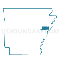
Outline

Summary
| Unique Area Identifier | 528010 |
| Name | FORREST CITY WARD 2 BOX 2 PCT 44 |
| County | St. Francis County |
| State | Arkansas |
| Area (square miles) | 0.26 |
| Land Area (square miles) | 0.26 |
| Water Area (square miles) | 0.00 |
| % of Land Area | 100.00 |
| % of Water Area | 0.00 |
| Latitude of the Internal Point | 35.01186550 |
| Longtitude of the Internal Point | -90.80332810 |
Maps


Graphs
Select a template below for downloading or customizing gragh for FORREST CITY WARD 2 BOX 2 PCT 44, St. Francis County, Arkansas


Neighbors
Neighoring Voting District (by Name) Neighboring Voting District on the Map
- COURTHOUSE WEST PCT 26, St. Francis County, AR
- FORREST CITY WARD 1 BOX 3 PCT 38, St. Francis County, AR
- FORREST CITY WARD 2 BOX 2 PCT 39, St. Francis County, AR
- FORREST CITY WARD 2 BOX 2 PCT 40, St. Francis County, AR
- FORREST CITY WARD 2 BOX 2 PCT 42, St. Francis County, AR
- FORREST CITY WARD 2 BOX 2 PCT 45, St. Francis County, AR